Join the community!
 Francais  Deutsch

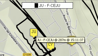
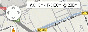
live.glidernet.org displays FLARM equipped aircraft in flight on a map. Their positions are recovered by a network of Flarm ground receivers and uploaded to this website via the InterNet. Each aircraft is represented by an icon with a 3 character identifier (this is either its competition number, the last 3 characters of its registration or _xx where xx is the last 2 characters of a randomly assigned hex ID). A coloured line on the map represents the track of each aircraft. A list of all aircraft in flight is displayed in a panel at the side of the window and shows the identifier of the aircraft, the colour of its track, its altitude and its vertical speed (Vz).
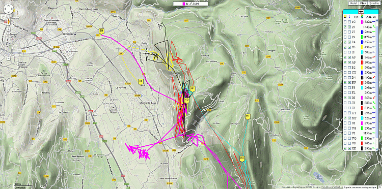
..:: Lists and Menu Panel ::..

Pressing the TAB key or clicking on the header label OnLine, OffLine or Menu rotates this panel through a sequence of 3 pages.

The default condition is that all aircraft for which data has been available within the last 10 minutes are displayed in the OnLine list. If there has been no data for an aircraft after a period of 10 minutes then it goes into the OffLine list.

To hide the panel you must click on the icon. To make the panel reappear you must click on the icon.
To switch the panel to the other side of the screen (left / right) you must click the double arrow icon.
To view this help page, click on the icon.

The Menu page enables the user to access the map display controls:
- The checkbox "Hide new gliders" prevents new gliders that are picked up by the network from being displayed.
- The checkbox "Ignore Offline" disables the OffLine page.

- The checkbox "Bounds" limits the OnLine and OffLine lists to show only gliders within the geographical boundaries specified in the boxes below:
The "Set to map" button adjusts the boundaries to be those of the current map display.
- The checkbox "Auto Set to map" allows the boundaries to be continually updated as the map is zoomed and panned.

The "..:: Layers ::.." section shows or hides additional layers on the map which are self explanatory:
- Receiver status
Green: Receiver online and active
Red: Receiver offline or inactive


-Tasks: click on 'Tasks' to load a task file

Units:
Check 'Met.' for metric or 'Imp' for imperial

Path length
You can set the path length for each aircraft to 5 minutes, 10 minutes or unlimited (all)

Altitude
Check 'Altitude stick' to show a gauge under each icon proportional to the altitude of the aircraft.
Check 'Barogram' to display the barogram window.


Column headers:     
A double-click on shows or hides all icons.
A double-click on shows or hides all traces.
A click on CN sorts the list in alphabetical order of IDs (another click will sort in reverse order).
A double-click on erases the tracks of all aircraft.
A click on Alti. sorts the list in order of ascending altitudes (another click will sort in reverse order).


Individual aircraft lines:     
Unchecking or checking the first box hides or shows the icon of the aircraft.
Unchecking or checking the second box hides or shows the track of the aircraft.
A click on the ID centers the map on the aircraft icon (momentarily if automatic centering is active on another aircraft).
A double-click on the ID (or the icon of the aircraft in the map) activates automatic centering on the aircraft icon in the map.
A right-click on the ID (or the icon of the aircraft in the map) displays the complete track for the aircraft for the day.
A right-click on the coloured rectangle changes the colour of the track that is assigned to the aircraft (looping through 9 possible colours).
A double-click on the coloured rectangle clears the aircraft's track for the day.
A click on the altitude (or the icon of a aircraft in the map) brings up a detail panel containing the information registered on Devices DataBase for the aircraft.

Ranges of Vz icons:
Vz > +4m/s
+4m/s ≥ Vz > +1m/s
+1m/s ≥ Vz > 0m/s
Vz = 0m/s
0m/s > Vz ≥ -1m/s
-1m/s > Vz ≥ -4m/s
-4m/s > Vz
Inactive, no data received for more than 2 min.


..:: The map ::..
Yellow: Gliders and motorgliders
Green: Tugs
Red: Helicopters
Pink: Hang-gliders and paragliders
Black: Drones and unmanned aircrafts
Blue: Other aircraft
Grey: All inactive aircraft (no data received for the last 10 minutes)

On the map, hovering the mouse over an icon or track displays the ID and registration of the aircraft on a label at the top center and highlights the track of the aircraft.
Hovering the mouse over an icon highlights the line in the list for that aircraft and momentarily displays a bubble with its ID, registration, altitude and time of the last data received.
A click on the icon of a aircraft (or the altitude of the aircraft in the list) brings up the detail panel containing the information held on Devices DataBase for the aircraft (clicking on this panel closes it).


A double-click on the icon of a aircraft (or the identifier of a aircraft in the list) activates automatic centering on that aircraft.
A label at the top left shows which aircraft automatic centering (AC) is active on.
To disable automatic centering, click on this label.

A right-click on the icon of a aircraft (or the identifier of a aircraft in the list) displays the complete track for that aircraft for the day.


A right-click on the background map shows the topographic elevation and geographical coordinates of the clicked point.